Unmanned aerial ignition
By: Kevin Ihaka, Managing Director of FPS group of companies, TFF Committee Member
Why?
While large-scale controlled burning was common up to the 1990s, the use of fire on large scale burns has significantly declined over the years.
This decline is due to a variety of reasons:
- Concerns over smoke pollution
- High cost of ignition and containment
- Risk of the fire escaping
- Public perception around carbon emissions
- Loss of skills and knowledge to manage burns safely and effectively.
I was involved in large scale burns during the 1980s when thousands of hectares were burnt for new forest establishment and to a lesser degree ever since then.
As listed above there are a few reasons for this decline but I am strongly of the belief that prescribed burning has a very important role to play in sustainable forestry, land development and fuels management. As forest harvesting has become more mechanised there has been a corresponding increase in logging slash left on the hillside that would have previous been stacked on a landing.
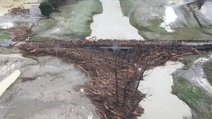
The images of slash in flooded rivers and covering beaches is a grave threat to our social licence to operate in plantation forestry. These incidents are tremendously damaging environmentally and socially.
The increase in slash “on the hill” presents issues for planting crews who must plant through these areas, often resulting in sub-optimal stocking and tree placement, an increase in time taken and elevated risk of slips and trips for the planters. Alternatively mechanical ground prep is used where topography permits, adding costs and increasing the carbon footprint. Even burning landings has fallen out of favour with some owners, although they are relatively easy to burn and control.
Smoke pollution
While smoke is a particular issue near built up areas it can be managed to minimise the risk simply by monitoring and understanding the weather. There are some very good smoke modelling systems available but generally smoke drift can be interpreted by predicted wind direction and the ventilation index.
Cost
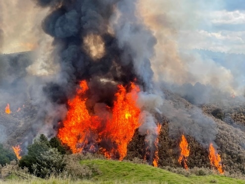
Ignition patterns and sequences are the key to successful burns, and arguably the cause of many failures. Handheld burners put operators in high-risk situations that require meticulous planning and clear reliable communications to keep operators safe.
Given the need to sometimes cover large areas quickly or ignite internal pockets in a timely and effective manner, hand ignition is often not suited to all areas of large-scale burns, therefore requiring a helicopter for aerial ignition.
The most common device for use with a helicopter is the aerial drip torch. These igniters can be fickle and need an experienced pilot with a full understanding of the burn plan and the ability to assess the effectiveness (or not) of their drops. While a very useful tool in large scale and remote burns, experienced pilots are increasing hard to find due to the lack of this type of work and there is obvious cost implication for the use of a helicopter.
Risk of escape
All fires present the risk of an “over-achievement”, but this can be minimised by good planning, weather forecasting and effective ground crews.
Ground crews are not cheap when large numbers are deployed, so to be efficient we need to minimise the number required and deploy well trained crews to where they are needed. Reducing the number tied up in ignition operations and allowing them to concentrate on containment presents good savings.
An eye in the sky is the best tool for tracking a fire and checking for spot fires, ground crews have limited visibility and will often only see an escape once it has developed to a sizable fire. Again, traditionally this is a function for a helicopter.
Public perception
Unfortunately, the public are exposed to media constantly portraying “bad” fire and very little about fire as a tool. There is much work to be done here to educate the public about the benefits of burning, an opportunity that could arise out of bad publicity surrounding slash migration incidents or large-scale bushfires overseas where prescribed fuel reduction burning has not taken place for the same reasons we see in New Zealand.
There is a public perception that burning increases carbon emissions, this again needs education around the fact that we are simply accelerating the process.
Loss of skills and knowledge
As an experienced fire manager, I have seen the decline in burning skills used in fire response. Traditionally the skills gained at large scale burns served us well at all levels from the firefighters dealing with fire escapes to the managers and planners of burns.
The lack of these skills adds significantly to firefighting costs where fires are extinguished where they appear rather than managed to boundaries, burnt out breaks and natural barriers. All things we utilise in controlled burns.
My view is that these skills only come from experience “playing with fire”, the skill to predict, plan and manage the way a fire behaves.
UAVs and the future
UAVs have already established roles in fire observation and detection using cameras and infrared sensors, tracking and mapping hotspots and fireground mapping.
We are seeking to expand the role they must include fuel mapping and ignition.
Currently we are trialling two ignition systems, the ‘Ignis 2’ and the ‘Throw flame Wasp’. The Ignis uses potassium permanganate “eggs” for ignition and the Wasp uses thickened fuel.
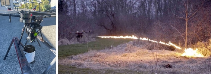
These machines have very different roles. The Ignis is better suited to ground level ignition as the balls sit on the ground before they ignite while the wasp will ignite aerial vegetation if that is where it lands. The Wasp has limited duration and coverage due to the need to carry a load of liquid fuel. The ignis can carry over 400 “Dragon Eggs” so can cover a wide area without the need to refill.
UAV ignition will remove crews from ignition roles and free them to contain the fire while greatly reducing costs and risk associated with helicopter ignition.
Both devices work with both a camera and infrared sensor to give valuable intelligence back to the pilot about the ignition process and the progress of the fire. The UAV can immediately revert to an observation role at any time.
Application of these tools is dependent on having experienced fire managers to direct and plan the burn, but as we grow our knowledge and experience, we will have better data around ignition thresholds and trigger points for weather conditions.
We have a forest engineering student researching the ignition thresholds for pine logging slash so that we can determine a range of weather and fuel conditions where ignition is possible, and then overlay this with the conditions required to successfully contain the fire so we can develop weather and fuel trigger points for safe effective burning.
Further to our work on the thresholds we will work with harvesting contractors to investigate practices for mechanised harvesters to position slash for optimal results. This work will be coupled with UAV fuel density mapping to direct the ignition drops for best ignition and containment.